
Find areas of unconstrained land across the UK
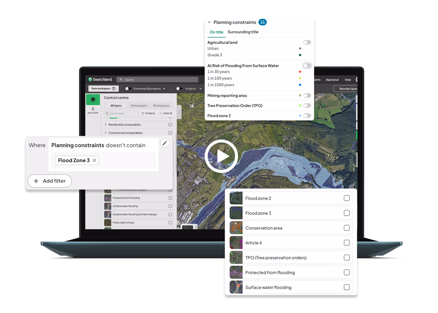
Planning constraints
We’ve connected planning constraints directly to land titles and our sourcing engine - with every dataset available as a visual layer for complete clarity.


Stack layers, see more
Searchland blends planning constraints with land titles in a single, intuitive map. Visual layers make it easy to spot development-ready plots fast.
Strategic insights at a glance
Access detailed maps covering flood zones, conservation areas, and agricultural constraints - saving you hours of research and comparison.
Some of the constraints available in Searchland
We’ve saved you hours of work of sourcing and comparing strategic land maps by adding all of these together onto the Searchland platform.
Flood zone 2
Flood zone 3
Conservation area
Protected from flooding
Surface water flooding
Public rights of way
Green belt
National Landscapes (AONB)
Ancient woodland
SSSI
SSSI impact zone
National Parks
Country parks
CRoW
National nature reserve
Local nature reserve
SPA
Special area of conservation
RAM SAR
Agricultural land
Nutrient neutrality
Listed buildings
Scheduled monuments
Registered parks & gardens
World heritage sites
Battle fields
London constraints
LSIS
SIL
ULEZ (Proposed)
ULEZ (Current)
Areas of intensification
Low emission neighbourhood
Low emission zone
Opportunity areas
Town centre boundaries
Designated open spaces
National forests & land
Scottish wild land areas
More features

Energy & DNO Data
Substations, connection capacity, embedded capacity trends
Learn More


Strategic land
SHLAA sites, settlement boundaries, 5-year housing land supply and other national datasets
Learn More

Letter sending
Bulk send thousands of letter campaigns in a few clicks.
Learn More

Sourcing tool
Custom criteria filters & radius searches - powered by AI
Learn More

Planning constraints
Find areas of unconstrained land in the UK
Learn More

Ownership
Map multiple ownership data layers in one comprehensive visualisation
Learn More

Residential comparables
Real-time, on-market rental and sales data
Learn More
%203.svg)
Traffic & footfall
Accurate traffic, footfall and transportation data
Learn More

Biodiversity net gain
Habitat screening & habitat bank sourcing
Learn More

Planning applications
Access 30 years of historical planning data
Learn More

HMO data
Access national HMO license data including expiry date
Learn More

Commercial comparables
Commercial sales, lettings and leasehold data
Learn More

Title reports
View title data and generate concise reports
Learn More

Land values
Exclusive access to land value, promotion and planning data
Learn More

Demographic data
See the population trends that impact development
Learn More
Powered by Ordnance Survey, HM Land Registry, Rightmove and more


%201.avif)


Planning Data updated every 24 hours, Rightmove data updated weekly & Policy data updated within 7 days of release.
Lorem ipsum dolor sit amet
Mass send letter campaigns to landowners of interest directly from the platform
Read More


.webp)


%20(1).webp)
