Align with local planning objectives
Strategic land data
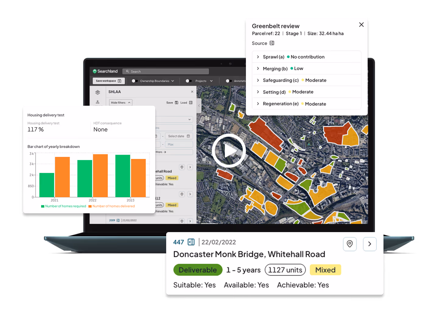
Use SHLAA sites, site allocations, settlement boundaries, and Brownfield registers, alongside our interactive local plan tool -to find opportunities aligned with planning policy from the start.

Strategic datasets available in Searchland
We’ve combined all the essential strategic land datasets into one platform—saving you hours of sourcing and comparison so you can focus on action.
Settlement boundaries
Five year land supply
Local plan positions
Housing delivery test
SHLAA
Land allocation
Local plan policy
Brownfield land
Green Belt Review

Simplify sourcing with Strategic Land Data
Settlement boundaries, five-year land supply, local plan status, housing delivery test results, Green Belt Reviews, Brownfield Registers, SHLAA, and more
Find the right land at the right time
Unlock high-potential land opportunities by overlaying multiple datasets -pinpoint areas with housing demand and identify sites primed for value uplift.

Filter all the datasets
Easily filter SHLAA, Site Allocations, and Brownfield land data to surface the sites that match your exact needs.

Local Plan Data, simplified
No more trawling through council policy maps. We’ve extracted the key data and built it into our interactive local plan policy tool - so you get the insights without the hassle.

See the bigger picture
Overlay multiple data layers to unlock deeper insight. Spot trends and make informed predictions on settlement boundary extensions using approved SHLAA sites.
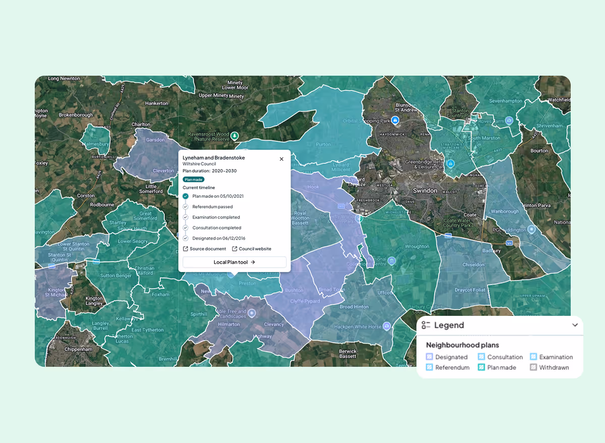
Neighbourhood Plans, in one place
Stop searching council websites for hyper-local policy. We've added 3,000+ Neighbourhood Plans across 300+ councils - boundaries, status, and source documents in a single click.
More features

Energy & DNO Data
Substations, connection capacity, embedded capacity trends
Learn More


Strategic land
SHLAA sites, settlement boundaries, 5-year housing land supply and other national datasets
Learn More

Letter sending
Bulk send thousands of letter campaigns in a few clicks.
Learn More

Sourcing tool
Custom criteria filters & radius searches - powered by AI
Learn More

Planning constraints
Find areas of unconstrained land in the UK
Learn More

Ownership
Map multiple ownership data layers in one comprehensive visualisation
Learn More

Residential comparables
Real-time, on-market rental and sales data
Learn More
%203.svg)
Traffic & footfall
Accurate traffic, footfall and transportation data
Learn More

Biodiversity net gain
Habitat screening & habitat bank sourcing
Learn More

Planning applications
Access 30 years of historical planning data
Learn More

HMO data
Access national HMO license data including expiry date
Learn More

Commercial comparables
Commercial sales, lettings and leasehold data
Learn More

Title reports
View title data and generate concise reports
Learn More

Land values
Exclusive access to land value, promotion and planning data
Learn More

Demographic data
See the population trends that impact development
Learn More
Powered by Ordnance Survey, HM Land Registry, Rightmove and more


%201.avif)


Planning Data updated every 24 hours, Rightmove data updated weekly & Policy data updated within 7 days of release.
Lorem ipsum dolor sit amet
Mass send letter campaigns to landowners of interest directly from the platform
Read More


.webp)